5 Long Distance Trails in Singapore to Burn Off Those Bubble Tea Calories!

  • Reading time:6 mins read
You are currently viewing 5 Long Distance Trails in Singapore to Burn Off Those Bubble Tea Calories!

Lace up and explore Singapore with these five long-distance trails that takes you around some of Singapore’s best nature parks and attractions!

As Asia’s Greenest City, Singapore is home to over 350 parks and 4 nature reserves that complement our city landscape. Several walking trails have since been established around Singapore to allow Singaporeans to get up close and personal with nature.

While Singapore may be a Little Red Dot, there are several long distance trails that may prove to be too difficult to take on even for the experienced.

1. Coast to Coast Trail (36km)

Trail map of Singapore coast to coast trail
Coast to Coast Trail | Image credits: NParks

Start Point

Jurong Lake Gardens

End Point

Coney Island Park or Rower's Bay Park

Highlights:
Jurong Lake Garden
Macritchie Reservoir Park
Sengkang Floating Wetland
Punggol Waterway Park
Coney Island Park
Lower Seletar Reservoir Park

Established in April 2019, the Coast-to-Coast (C2C) trail is a 36km long trail that spans diagonally across Singapore. A total of 10 checkpoints have been established along the trail. Starting from Jurong Lake Garden, hikers navigate through 18 parks and 11 park connectors before reaching Coney Island Park and ending at Lower Seletar Reservoir Park (Rower’s Bay).

A mobile app was developed to provide an interactive walking experience through the use of augmented reality (AR). The mobile app offers real-time navigation and checkpoints where points can be earned and redeemed. Hikers can also upload photos of their hike and share with the local outdoor community.

Resources:
C2C PDF Trail Guide
C2C Mobile App

2. Central Urban Loop (36km)

Map of Singapore Central Urban Loop
Central Urban Loop | Image credits: NParks

Start Point

Toa Payoh Town Park

End Point

Toa Payoh Town Park

Highlights:
Bishan’s iconic HDB architecture
120 Steps staircase @ Ang Mo Kio Town Garden
Punggol Waterway Park (aka Venice of Punggol)
Kallang Park Connector

Similar to the Coast-to-Coast trail in distance, the Central Urban Loop (CUL) stretches 36km but in a circular loop, connecting the North Eastern Riverine and Eastern Coastal loops. The completion of CUL gives residents from Ang Mo Kio, Hougang and Serangoon easier access to East Coast Park and Pungol Waterway.

The completion of the CUL loop in 2015 also marked the 300km milestone of Singapore’s Park Connector Network.

Resources:
CUL Loop PDF Trail Guide

3. Eastern Coastal Loop (42km)

trail map of Singapore eastern coastal loop
Eastern Coastal Loop | Image credits: NParks

Start Point

Sun Plaza Park

End Point

Sun Plaza Park

Highlights:
Pasir Ris Park
East Coast Park
Changi Beach Park
Mangrove Boardwalk & Bird-Watching Tower
Changi Point Ferry Terminal
Bedok Reservoir Park

The Eastern Coastal Loop (ECL) (also known as the Eastern Coastal Park Connector Network) spans 42km across seven park connectors in the East. With ECL, cyclists and hikers can now visit popular beach parks such as East Coast Park, Changi Beach Park and Pasir Ris Park.

Various amenities and facilities such as car parks, toilets and eateries are scattered along the coastal trail, making it one of the most convenient trails in Singapore. If you are up for the challenge, participate in one of the water sports found along the trail, or even take a bumboat from the Changi Jetty for a quick visit to Pulua Ubin!

Resources:
ECL Loop PDF Trail Guide

4. North Eastern Riverine Loop (26km)

Map of Singapore North East Riverine Loop
North Eastern Riverine Loop | Image credits: NParks

Start Point

Punggol Park

End Point

Sengkang Riverside Park

Highlights:
Kampung Lorong Buangkok (The last kampung in Singapore!)
Lorong Halus Wetland
Coney Island
Punggol Point Park
Sengkang Riverside Park

Stretching across Buangkok, Sengkang, Pungol and Hougang, the 26km long North Eastern Riverine Loop (NERL) features the coastlines and waterways of the North East district.

In particular, the loop bypasses Punggol Jetty, Pungol Promenade and Lorong Halus Wetland, allowing hikers to have a glimpse at the Singapore’s natural biodiversity and take in the panoramic view of the Northeast coastline.

Resources:
NERL Loop PDF Trail Guide

5. Northern Explorer Loop (25km)

Map of Singapore Northern Explorer Loop
Northern Explorer Loop | Image credits: NParks

Start Point

Admiralty Park

End Point

Sembawang Park

Highlights:
26 slides @ Admiralty Park
Paranomic views of Johor @ Waterfront Park
Ulu Sembawang Park Connector
Sembawang Park
Lower Seletar Reservoir Park

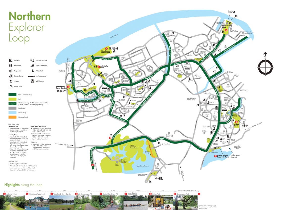
Connecting residents in Woodlands, Sembawang and Yishun, the Northern Explorer Loop (NEL) features 11 parks in the north, including Woodlands Town Garden, Admiralty Park and Woodlands Waterfront.

At Woodlands Waterfront Park, hikers can get a paranomic view of the Causeway and the Straits of Johor. For those looking for a quick bite, Rasa Istimewa Waterfront Restaurant (located at the edge of the jetty) offers a variety of Halal meals and deserts for hungry-goers.

Be sure to also check out the iconic “Rocket Tower” at Seletar Reservoir! Built in 1969, the same year that Apollo 11 landed on moon, the six-storey high tower offers a  breathtaking panoramic view of the surrounding waters and greenery.

Resources:
NEL Loop PDF Trail Guide

6. Western Adventure Loop (20km)

Map of Singapore Western Adventure Loop
Western Adventure Loop | Image credits: NParks

Start Point

Bukit Batok Town Park

End Point

Pang Sua PC

Highlights:
Xiao Guilin @ Bukit Batok Town Park
Poh Kim Quarry @ Bukit Batok Nature Park
Bukit Timah Hill @ Bukit Timah Nature Reserve
Zhenghua Park

The shortest of the six featured trails, the 20km long Western Adventure Loop (WEL) covers 8 parks located in the West including Bukit Batok Town Park (where Xiao Guilin is located), Dairy Farm Nature Park and Bukit Timah Nature Reserve.

For the less experienced, hike along Hillview Park Connector and walk along Dairy Farm Road to Zhenghua Park. Otherwise, take a walk along Bukit Timah Park Connector and summit the 164m tall Bukit Timah Hill before exiting to Zhenghua Park.

Be sure to check out the Rail Corridor which runs parallel to Pang Sua PC from Junction 10 to Yew Tee (end of park connect0r).

Resources:
WAL Loop PDF Trail Guide

BONUS: 150 km Round Island Route (by 2035)

Map of Singapore Round Island Route
Round Island Route | Image credits: The Straits Times

The Round Island Route (RIR) is a 150km long park connector that loops around Singapore, literally! The route complements the existing Park Connector Network and will connect several natural, cultural and historical sites to create an integrated hiking experience.

The first 60km of the RIR between Rower’s Bay and Gardens by the Bay have been connected via Sengkang Riverside Park. The route will be extended to 120km by 2021 with the completion of another 60km of path between Gardens by the Bay and Rower’s Bay via the Singapore River and Rail Corridor.

The full, 150km route extends the western section of the RIR, connecting Gardens by the Bay to Jurong Lake Gardens (via the Rail Corridor) before heading up north to Kranji and Admiralty.

With that said, the full RIR is slated to complete only in 2035. Sorry to disappoint ultra marathon runners out here!

Want to know the latest outdoor, sports and fitness events and promotions in Singapore?

You May Like

It seems we can't find what you're looking for.

Leave a Reply